Sunday, November 18, 2007
Saturday, July 14, 2007
Seneca College's King Campus
 Eaton Hall
Modeled after a Norman French chateau with rounded turrets and grand halls. It started as a summer residence and working farm. It was the site of many Hunts of the Toronto and North York Club. During the Second World War it was a hospital for severe burn patients. And, since 1971 it has been the location of one of Canada's outstanding community colleges.
Sunday, July 1, 2007
Crawford Lake and Rattlesnake Point
 Crawford Lake Conservation Area is located at Steeles Avenue and Guelph Line, 5 km. south of Highway 401 and 15 km. north of the Q.E.W.
 "The Crawford Lake Conservation Area includes 19 km of spectacular hiking, cross-country skiing and snowshoeing trails on Ontario's scenic Niagara Escarpment."
 We hiked around the lake to look at the environment there and take some photos. Got lucky to see and to take photos of the some fish and turtle. We think they come out to see if they can get food from the hikers. Although, it is not allowed to feed fish in the lake.
 From the Crawford Lake we went to see Rattlesnake Point. It took as 3.5 hours to return and we got a bit lost and had to walk on the road for around 2-3 km. The whole journey was about 16 km - our longest so far.
 "For the adventuresome, Rattlesnake Point has three designated sites where experienced rock climbers can scale challenging cliffs under a canopy of rich woods. Hiking enthusiasts can trek the Bruce Trail through the Nassagaweya Canyon complete with trail connections to Crawford Lake." Photo by Neil Hester
 We did a bit of rock climbing before returning to Crawford Lake and spoke to one of the instructors about climbing classes. He recommended Free Spirit Tours.
Sunday, June 24, 2007
Lake Wicox to Bathurst Glen Golf Club
Sunday, June 17, 2007
Belwood Lake, Elora Cataract Trailway, Ontario
 "A forty-seven kilometre trailway linking parks, watersheds and communities in south-central Ontario". Greate trail for biking, less interesting for the hikers, especially in the hot sunny day.
We parked at Belwood Lake Conservation Area and hiked to the beginning of the trail in Fergus and back. It was about 8 km and took us an hour and 45 minutes.

Sunday, June 10, 2007
Loon Lake, Haliburton Village, Ontario
 We hiked around the Loon Lake. We took Norman road until it ended and went through the forest. We had to cross a creek to get to the beginning of the trail.
 The trail ended at the camp and we took a road that lead to one of the cottages. We saw a pine tree that was destryoed by the lighting just day before.
Sunday, June 3, 2007
Albion Hills, Ontario
Sunday, May 13, 2007
Short Hills Provincial Park, Ontario
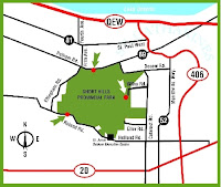
 We drove to the park from St. Catherines while on a break for the Shaw Festival. We got lost on the way looking for a stables where we can rent a horse for a day. There are planty of the stables aroung, none of them rent, though.
 This is quite big and very interisting park with many trails and connected to (part of) the Bruce Trail. Park information on the Ontario Parks website can be found here
 For more detailed information regarding the park please go to the Friends of Short Hills Park
Sunday, May 6, 2007
Hilton Falls (Bruce Trail), Ontario
Subscribe to:
Comments (Atom)


